Siting Farmlands in Pennsylvania for Biomass Energy Production
Abstract
This GIS analysis attempts to apply a future use for industrial hemp in the United States, more specifically in Pennsylvania. It references the United States lack of utilization for development of this agricultural commodity as the US is the only developed country where industrial hemp growth is still federally illegal. Since hemp can have many different applications and uses, this report employs the alternative energy aspect of the crop. More specifically the use of hemp as a crop to be used for biomass energy production from farmers utilizing it for rotational farming. This report attempts to find the most suitable locations in Pennsylvania based upon specific transportation criteria, climatic data, distribution of existing farmlands and biomass energy power plants. It was found that 9 out of Pennsylvania’s 67 counties host suitable farmland sites at the census tract level, with a total of 163 census tracts hosting suitable sites out of the state’s 3218 total tracts.
Research Objectives
The main objective of this analysis is to create a multi-criteria approach for site suitability regarding the potential future of industrial hemp farming in Pennsylvania. Further, this site suitability uses vector and raster approaches to determine what areas in Pennsylvania could utilize industrial hemp for rotational crop farming. The utilization of hemp for rotational farming is further explored in regards to the spatial relationships of state biomass energy production plants, as this crop can be utilized for alternative energy.
Data
Multiple types of data and shapefiles were obtained from a variety of sources. Tiger vector (polygon) shapefiles were obtained through the United States Census Bureau in the form of Pennsylvania Counties and also Pennsylvania Census Tracts (2015). Additionally, the 2013 US Census Tiger vector (line) shapefile for Pennsylvania Roads was obtained for transportation evaluation. The 2011 National Land Cover Database by the Multi-Resolution Land Characteristics Consortium provided the raster image utilized to determine potential farmlands in Pennsylvania. The 2009 United States Biomass Resource Assessment vector (polygon) shapefile was retrieved via Pennsylvania Spatial Data Access (PASDA) for biomass energy production information by Pennsylvania counties; which was organized by Anelia Milbrandt. The US Energy Information Administration provided addresses and power capacity of biomass power plants in Pennsylvania (2012); organized by the US Department of Energy. Pennsylvania county regions precipitation data (2015) was collected through the College of Earth and Mineral Sciences at Penn State University and retrieved from “The Pennsylvania State Climatologist” website. All shapefiles were projected in Pennsylvania State Plane South.
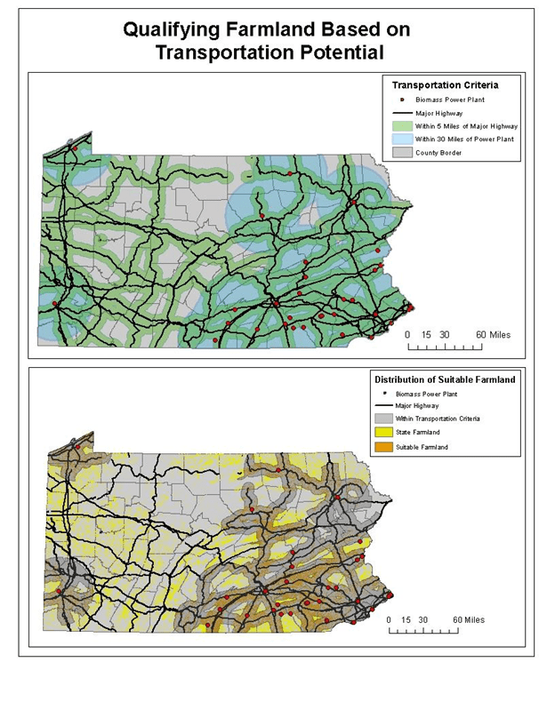
Criteria
A few forms of criteria were considered in the analysis for siting suitable farmlands to employ Industrial hemp as a rotation crop for biomass energy production. The final site criteria determined for most suitable are as follows:
- Within 5 miles of a major highway
- Within 30 miles of a biomass energy production plant
- In a county region with at least 3.2 inches of rain per month during the growing season
- In a county that uses crops for 25% or more of their biomass energy production
- In a Census Tract with at least 40% suitable farmland
Results and Discussion
After the methods were performed and applied, a total of 163 Census Tracts in 9 counties were considered suitable areas for the utilization of industrial hemp farming; Adams, Berks, Chester, Cumberland, Lancaster, Lebanon, Lehigh, Northampton, and York counties making up the list. Of these counties, Lancaster County possessed the highest amount of suitable Census Tracts at 41 total, far more than any other county. The ten tracts with the densest amount of suitable farmland consisted of 3 tracts within Berks County, 4 in Cumberland County, 2 in Lancaster County, and 1 in York County. The Census Tract with the most potential is in Berks County with almost 71% farmland in an area of 68.5 square miles and a farmland density of 48.5 square miles. Though there is a cluster of suitable locations connected to each other in Cumberland County as well.
Mapping Graphics